Big Sur Drive Road Trip Itinerary: Personal Highway Guide
If you’re looking for the ultimate road trip, Big Sur on California’s Pacific Coast Highway should be at the top of your list. I’ve always heard about its breathtaking views, but when I finally experienced it, I was blown away. The rugged coastline, towering redwoods, and winding cliffs make every mile worth the drive.
Whether you’re a seasoned traveler or just someone looking for a scenic escape, this guide will walk you through everything you need to know to make your Big Sur road trip unforgettable.
Ready to hit the road? Let’s dive into the adventure of a lifetime!
Table of Contents
Big Sur at a Glance (Trip Basics)
Big Sur is one of those places you just have to visit if you’re driving along California’s Pacific Coast Highway. It’s like a dream come true for nature lovers and road trip enthusiasts. The drive stretches about 90 miles from Carmel-by-the-Sea to San Simeon, and the views? Absolutely stunning!
Here’s a quick look at what to expect:
- Location: Big Sur is located between Carmel-by-the-Sea and San Simeon, along Highway 1 (also known as the Pacific Coast Highway).
- Distance: Roughly 90 miles (about 145 km) of breathtaking coastline.
- Typical Drive Time: It’ll take you about 2–3 hours if you’re driving straight through without stopping, but trust me, you’ll want to take your time.
- Fees: Some of the state parks charge about $10–$15 for day passes. Keep in mind, some beaches or parks might charge a little extra.
- Cell Service: You won’t have full cell service all the way through, so it’s a good idea to download offline maps before you head out.
- Best Season: While you can visit year-round, the best time is from April to October. The weather’s perfect, and it’s great for spotting wildflowers in the spring and watching whales in the fall.
What Is Big Sur?
Big Sur is one of those places that truly lives up to the hype. It’s famous for its dramatic coastal views, towering cliffs, and lush, green forests. But what exactly is Big Sur?
In simple terms, Big Sur refers to a stretch of California’s coastline between Carmel-by-the-Sea and San Simeon, all along Highway 1. It’s an area known for its rugged beauty, offering jaw-dropping views of the Pacific Ocean.
But Big Sur isn’t just about looking at pretty views. It’s a natural wonderland, filled with miles of hiking trails through redwood forests, secluded beaches, and the wild, crashing waves of the ocean. If you love outdoor adventures, this place has something for everyone. Whether you’re a hiker, a photographer, or someone who just wants to relax, you’ll feel like you’re in paradise.
Here’s why Big Sur is so special:
- The Scenery: Highway 1 gives you panoramic views of the ocean and cliffs. Trust me, every turn offers a new spot for an epic photo.
- Hiking: You’ll find some of the best hikes in California, from short trails to full-day treks through towering forests and rugged terrain.
- Peace & Quiet: Despite being a popular spot, many parts of Big Sur feel wonderfully isolated, giving you that sense of being away from it all.

From San Francisco to Big Sur
If you’re flying into San Francisco, it’s an easy 2-hour drive down to Carmel-by-the-Sea, which marks the northern end of Big Sur. From there, you can start your journey down Highway 1, enjoying those sweeping views right from the get-go.
- Route: Take Highway 101 South to Highway 1 South, and follow it to Carmel.
- Mileage & Time: About 120 miles (2 hours), but you’ll want to take your time because the drive is stunning.
- Parking Note: Parking can get crowded, especially at popular stops like Point Lobos and McWay Falls, so plan ahead.
From Los Angeles to Big Sur
For those starting from Los Angeles, it’s a bit of a longer drive, but trust me, it’s worth it. You’ll pass through beautiful scenery, and if you’re coming from the south, you’ll have different perspectives of the coastline.
- Route Options: You can take Highway 1 or Highway 101 (I recommend Highway 1 for the scenic route). The drive from LA to Big Sur typically takes about 4 hours.
- Tips for Driving South to North: If you’re coming from Los Angeles, starting your drive north to south will give you the best views of the ocean, especially when you drive through Bixby Creek Bridge and McWay Falls.
- Map Embed Placeholder: (This is where a Google Maps link would be helpful for easy navigation.)
Best Time To Visit Big Sur
When is the best time to visit Big Sur? The good news is that Big Sur is beautiful year-round, but the experience will vary depending on the season. Here’s a quick look at what you can expect throughout the year:
- Spring (March – May): Spring is one of the best times to visit! The weather is mild, and you’ll see incredible wildflowers in bloom, especially in April. It’s also not as crowded as summer, so you can enjoy the views without the rush.
- Summer (June – August): Summer is the peak season, so expect more visitors. The weather is warm and pleasant, but because it’s so popular, some spots can get crowded, especially on weekends.
- Fall (September – November): Fall is another fantastic time to visit. The temperatures are mild, and you’ll still have great weather. Plus, this is whale-watching season, so you can catch a glimpse of the migrating gray whales.
- Winter (December – February): While winter is the quietest time to visit, it’s also the most unpredictable. It’s less crowded, but the weather can be rainy and foggy. However, you’ll still experience the stunning coastal beauty, and the tranquility of winter in Big Sur is worth it.
Here’s a quick breakdown of the weather by month:
| Month | Average Temp | Rainfall (inches) |
|---|---|---|
| March | 55°F – 65°F | 4.0 |
| April | 57°F – 68°F | 2.5 |
| May | 59°F – 72°F | 1.2 |
| June | 60°F – 75°F | 0.5 |
| July | 63°F – 78°F | 0.0 |
| August | 63°F – 78°F | 0.0 |
| September | 62°F – 77°F | 0.2 |
| October | 58°F – 70°F | 1.0 |
| November | 54°F – 65°F | 2.5 |
| December | 50°F – 60°F | 5.0 |
- Best Months for Whale Watching: You’ll have the best chance of spotting migrating whales between December and April.
Road Conditions & Closures
While Big Sur is breathtaking, it’s important to be aware of the road conditions and potential closures. The area is prone to landslides, especially during the rainy season, which can affect your travel plans. Here’s everything you need to know:
- Landslides & Seasonal Closures: The Pacific Coast Highway (Highway 1) can experience occasional landslides, particularly after heavy rains. These can lead to temporary road closures, so it’s essential to check the road conditions before you go. Most closures are in the winter or early spring months when storms are more frequent.
- How to Check Live Updates: To stay on top of any closures or delays, you can check the CalTrans website or use their road status updates. This will give you real-time info on any road blockages or detours along the highway.
- Safety Tips:
- Fog & Limited Visibility: The weather along the coast can change quickly. Fog is common, especially in the mornings and evenings, so be sure to drive carefully and keep your headlights on.
- Narrow Roads & Limited Shoulders: Some stretches of the road are narrow and winding, so take your time. Keep an eye out for pullout areas to stop and enjoy the views, but be mindful of oncoming traffic.
- No Cell Service: Since there’s limited cell phone coverage in some parts of Big Sur, download offline maps ahead of time and have a paper map as a backup.
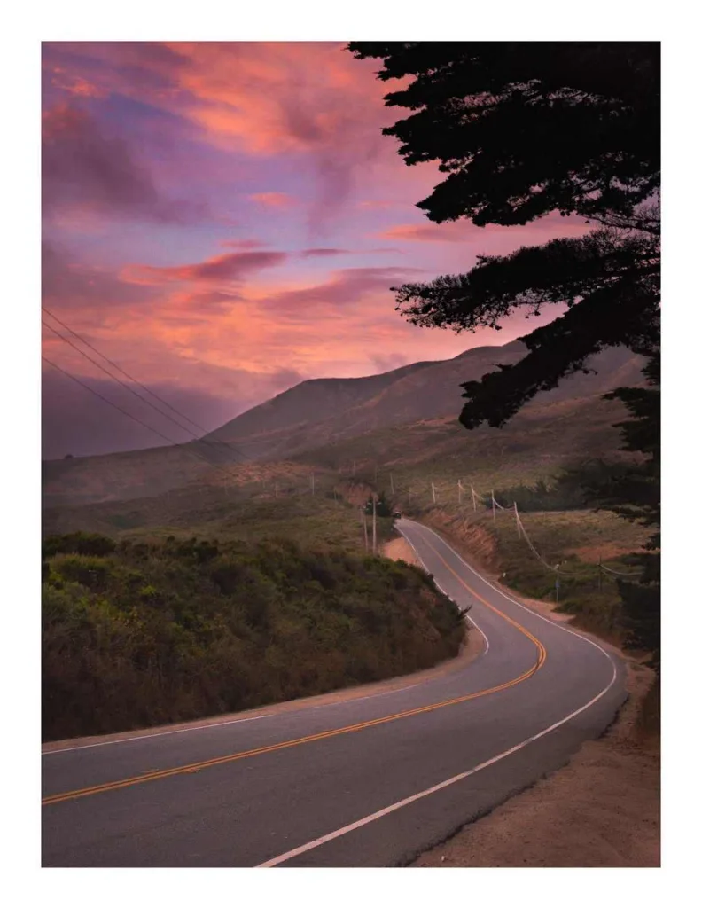
Which Direction Should You Drive Big Sur?
One of the most common questions travelers ask is whether to drive north to south or south to north along Big Sur. Both directions offer incredible views, but here’s what you should consider:
- North to South (Carmel to San Simeon): Starting from the north gives you better views of the coastline since you’ll be on the ocean-side of the highway. You’ll also get the benefit of seeing famous landmarks like McWay Falls and Bixby Creek Bridge with the best lighting in the late afternoon. If you’re planning to stop for photos, starting from Carmel allows you to pull off the road more easily.
- Pros: Best ocean views, ideal for afternoon/evening light, less traffic going south.
- Cons: You may miss some spots that are better seen heading the other way.
- South to North (San Simeon to Carmel): Driving south to north is great for early risers who want to catch the sunrise or have the road mostly to themselves in the morning. Point Lobos and Pfeiffer Beach are better experienced from this direction, and there are some hidden gems you can see up close without the crowds.
- Pros: Quieter mornings, more time for morning photos, sunrise at key stops.
- Cons: You’re on the inland side, so the ocean views are farther away.
Recommendation: If you have the time, driving north to south is generally the preferred option because the views are spectacular from that direction, and you can enjoy the best of the Pacific coast’s beauty.
Big Sur Road Trip Tips
A Big Sur road trip is unforgettable, but there are a few things you’ll want to keep in mind to make the journey even smoother. Here are some essential tips to ensure your trip is safe, fun, and stress-free:
Road Conditions & Closures (summary + links)
As we discussed earlier, Big Sur can experience landslides and seasonal closures due to weather. Always check for live updates on CalTrans before you go, especially during the rainy season. You can also find info about temporary detours if roads are closed due to land or mudslides.
Cell Service & Safety Notes (download maps, gas planning)
Cell service is spotty in many parts of Big Sur. To avoid getting lost or frustrated, download offline maps on your phone before heading out. It’s also a good idea to bring a physical map as a backup.
Another tip: Fuel up before you hit the road, as gas stations can be few and far between once you’re in Big Sur.
Permits, Fees & Parking Info (state park passes, Pfeiffer Beach notes)
Many state parks in Big Sur require a day-use fee (around $10–$15), and some of the popular spots, like Pfeiffer Beach, can have limited parking. If you’re planning to visit these spots, make sure you have enough time to find parking, especially during peak season. Arriving early is your best bet for avoiding crowds.
Wildlife & Ecology (sea otters, whales, condors — seasonal notes)
Big Sur is home to a rich variety of wildlife. Keep an eye out for sea otters in the water, whales migrating along the coast, and California condors soaring overhead. The best times to see whales are between December and April, while wildflowers bloom in spring.
Alternate Routes & Tours (17-Mile Drive, Carmel Valley road)
If you have time, consider taking a detour on the 17-Mile Drive for stunning views of the coastline, or explore Carmel Valley Road for a quieter route with less traffic. You can also opt for guided Big Sur tours if you want to learn more about the area’s history and wildlife while enjoying the drive.
Big Sur Road Trip Itinerary
Now that you know the basics and have a few tips under your belt, it’s time to dive into the Big Sur Road Trip Itinerary. I’ll break it down for you, from Carmel-by-the-Sea to San Simeon, including the must-see stops and a suggested timeline for your journey.
Here’s a map to help you visualize the route with distances and drive times between each stop:
Carmel-by-the-Sea
Start your Big Sur adventure in Carmel-by-the-Sea, a charming coastal town with fairy-tale cottages, art galleries, and cozy cafés. It’s the perfect spot to kick off your road trip with a little wander around town. Don’t miss out on the Tuck Box for a delicious breakfast scone before you hit the road.
Point Lobos State Natural Reserve
Just a short drive from Carmel, Point Lobos is one of the most scenic places in California. The trails here take you along the cliffs, where you’ll have breathtaking views of the Pacific Ocean. If you’re into wildlife, keep an eye out for sea otters, harbor seals, and pelicans. The Bird Island Trail is a great easy hike to start with.
Garrapata State Park
Garrapata is another gorgeous spot along the Big Sur coast. The Bluff Trail is a quick and easy hike that offers sweeping views of the ocean and the Santa Lucia mountains. If you’re there in spring, you might be lucky enough to catch the wildflowers in full bloom!
Garrapata Beach & Calla Lily Valley
Garrapata Beach is beautiful and peaceful, especially if you want to take in the views without the crowds. In February to March, the Calla Lilies bloom here, making it a perfect stop for nature lovers and photographers. Just be careful, as the area can get busy on weekends.
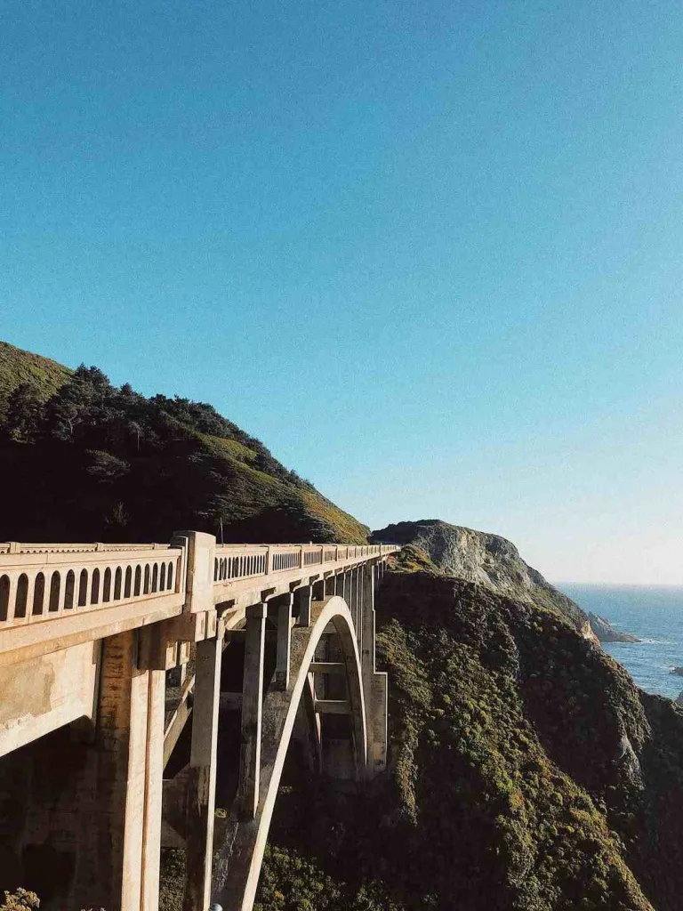
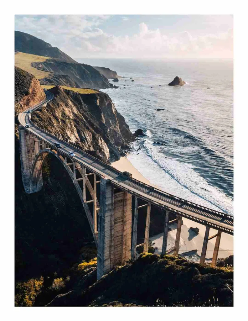
Bixby Creek Bridge
This iconic concrete bridge is one of the most photographed spots on the Pacific Coast Highway. The bridge spans a dramatic gorge, offering breathtaking views of the cliffs and the ocean below. It’s the perfect place for a photo op, especially around sunset.
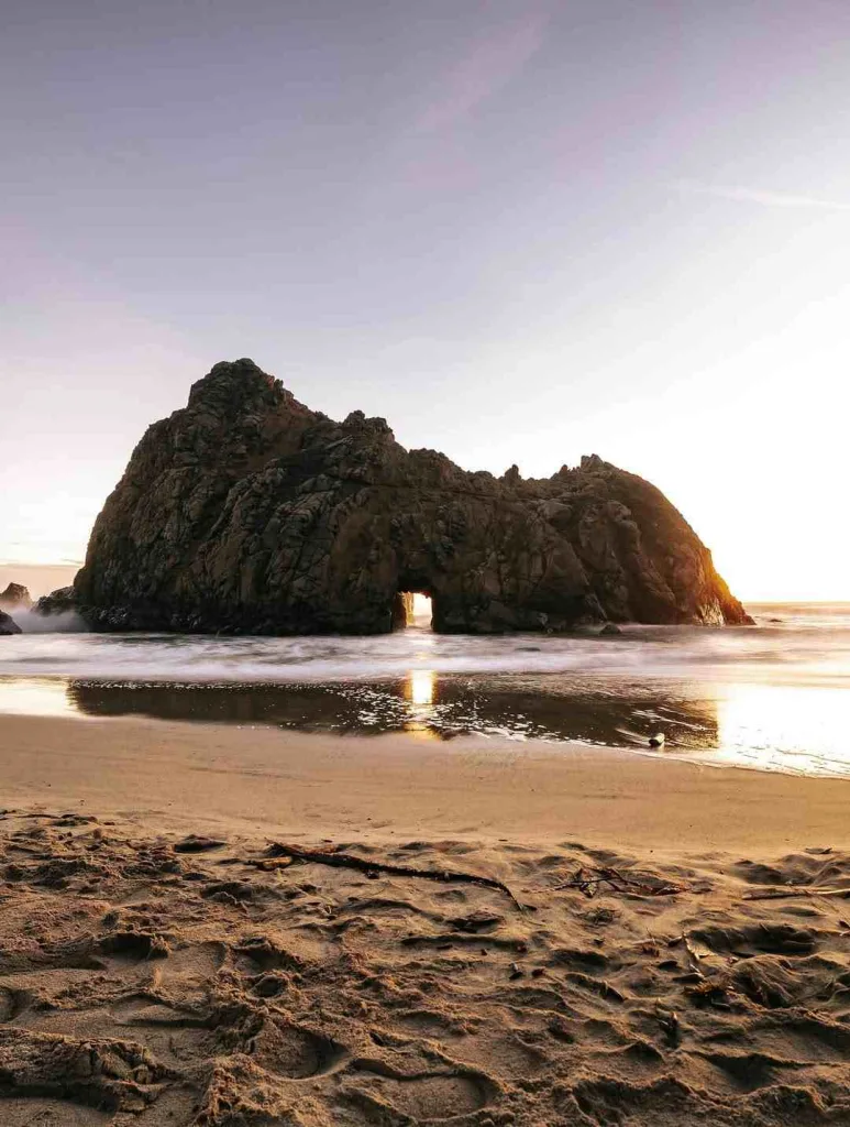
Pfeiffer Beach
Pfeiffer Beach is famous for its purple sand and unique rock formations. It’s a great place to stretch your legs, take a walk along the shore, or just enjoy the crashing waves. If you’re lucky, you might catch the sun shining through the Keyhole Arch at sunset — it’s a photographer’s dream!
Julia Pfeiffer Burns State Park & McWay Falls
McWay Falls is one of the most famous waterfalls in California, and it’s easy to see why. This 80-foot waterfall cascades directly into the Pacific Ocean. The view from the observation point is breathtaking, and the short hike through Julia Pfeiffer Burns State Park is a great way to explore the area.
Must-See Stops on a Big Sur Day Trip
If you only have one day in Big Sur, here’s a quick list of the must-see spots:
- Point Lobos – Scenic hiking and wildlife watching.
- Bixby Creek Bridge – Iconic photo opportunity.
- McWay Falls – A stunning waterfall that drops into the ocean.
Exploring Big Sur Over Multiple Days
If you’re lucky enough to have more than one day, here are a couple of itinerary suggestions:
- 2-Day Itinerary:
- Day 1: Start in Carmel and visit Point Lobos, Bixby Creek Bridge, and Pfeiffer Beach. Stay overnight at Big Sur Campground or Glen Oaks Big Sur.
- Day 2: Head to McWay Falls, Julia Pfeiffer Burns State Park, and explore Garrapata Beach before finishing your trip at San Simeon.
- 3-Day Itinerary:
- Day 1: Start in Carmel, explore Point Lobos, Bixby Creek Bridge, and Pfeiffer Beach.
- Day 2: Head south to McWay Falls, Julia Pfeiffer Burns State Park, and Garrapata State Park. Stay in one of the gorgeous Big Sur hotels or Airbnbs.
- Day 3: Explore San Simeon, visit Hearst Castle, and then enjoy a relaxing finish to your road trip.
Map & Mileage Table
| Stop | Distance from Previous Stop | Estimated Drive Time |
|---|---|---|
| Carmel-by-the-Sea | – | – |
| Point Lobos State Reserve | 5 miles | 15 minutes |
| Garrapata State Park | 10 miles | 20 minutes |
| Garrapata Beach & Calla Lily Valley | 2 miles | 5 minutes |
| Bixby Creek Bridge | 10 miles | 15 minutes |
| Pfeiffer Beach | 5 miles | 10 minutes |
| Julia Pfeiffer Burns State Park & McWay Falls | 5 miles | 10 minutes |
What To Pack
When you’re heading out on a Big Sur road trip, it’s important to be prepared for the adventure ahead. The weather can change quickly, and you’ll likely want to do some hiking or exploring, so layers are key! Here’s a comprehensive packing list to help you cover all your bases:
- Hiking Shoes: Comfortable, durable shoes are a must for exploring Big Sur’s trails. If you’re planning on some serious hiking, choose waterproof boots for extra comfort and protection.
- Merino Wool Socks: These are perfect for keeping your feet dry and blister-free on long hikes. Plus, they’re breathable and odor-resistant!
- Hiking Pants, Leggings, Shorts, Skorts, Dresses: Whether you’re hiking through the redwoods or just strolling along the beach, make sure to pack something comfortable and versatile for all types of weather.
- Quick-Dry Top: For hiking or just staying comfortable during your drive, a quick-dry top is essential. It’ll keep you cool and dry, no matter the weather.
- Day Pack/Hiking Backpack: A small pack to carry your essentials, like snacks, water, and a camera, is perfect for day trips or short hikes.
- Hip Pack: If you want to go lighter, a hip pack is a great alternative for short walks and quick stops.
- Trekking Poles: Not essential, but they can make hiking easier, especially on rocky or uneven terrain.
- Mid-Layer: A lightweight fleece or hoodie will keep you cozy when the mornings or evenings get chilly.
- Insulated Jacket: If you’re visiting in winter, or even early spring, pack an insulated jacket for extra warmth.
- Rain Jacket: The weather along the coast can change rapidly, so a rain jacket is a must to stay dry in case of showers or fog.
- Casual Clothes: You’ll want something casual for meals or relaxing after a day of hiking. Think comfy pants, T-shirts, or even something nicer if you’re planning to dine at a fancier spot.
- Navigation (Offline Maps, GPS): Download offline maps so you’re not relying on spotty cell service. A physical map is also a good backup.
- Emergency Beacon: Optional, but it’s always a good idea to have one if you’re heading into areas without cell service.
- Headlamp + Batteries: If you plan on hiking early in the morning or late in the evening, a headlamp can be a lifesaver.
- Drink Bottle + Water Jug: Staying hydrated is key, especially when hiking. A reusable water bottle plus a larger water jug for refills should do the trick.
- Sun Hat: A wide-brimmed hat will protect you from the sun, especially if you’re out on the trails all day.
- Sunscreen: Always pack sunscreen — you’ll need it even on cooler days.
- Sunglasses: Protect your eyes from the bright California sun with a good pair of polarized sunglasses.
- First Aid Items: Bring a small first aid kit with essentials like blister plasters, band-aids, and any medications you might need.
- Phone + Driver’s License/ID: Keep these with you in case you need them for renting equipment or accessing restricted areas.
- Camera + Batteries: Trust me, you’ll want to capture the views! Make sure your camera is charged and bring extra batteries or memory cards.
- Cooler: A small cooler to store snacks, drinks, or your lunch if you’re planning on stopping at one of the many picnic areas.
- Snacks: Bring along your favorite snacks, whether it’s trail mix, fruit, or granola bars. It’ll keep you fueled during long hikes.
- Reusable Coffee Mug: If you love your coffee, bring a reusable mug. It’ll save you from buying disposable cups, and you can sip your favorite brew on the go!
- Reusable Utensils: If you’re packing meals or picking up takeout, having a set of reusable utensils will help reduce plastic waste.
- National Parks Pass: If you’re visiting state parks or national parks, a park pass can save you money on entry fees. If you don’t already have one, you can pick it up online or at the park.
- Road Trip Playlist + Podcasts: Don’t forget to create a playlist for your trip and download some good road trip podcasts. Music and podcasts are perfect for those stretches of road where you just want to relax and enjoy the ride.

Where To Stay & Eat
Big Sur offers a range of accommodation options from camping under the stars to luxurious hotels with jaw-dropping ocean views. And as for food, you’re in for a treat with a variety of restaurants, cafés, and even some hidden gems along the way.
Big Sur Camping (selected campgrounds + reservation tips)
If you’re an outdoor enthusiast, camping in Big Sur is a must-do! Whether you’re pitching a tent or camping in an RV, you’ll have incredible views right from your campsite. Some of the most popular campgrounds include:
- Ventana Campground – Located in the heart of Big Sur, this luxury campground offers a more rustic experience with modern amenities.
- Pfeiffer Big Sur Campground – Nestled in the redwoods, this is a great spot if you want to camp surrounded by nature. Make reservations early during peak seasons!
- Big Sur Campground & Cabins – A family-friendly option with great spots for tent camping or renting cozy cabins.
Pro Tip: Some campgrounds fill up quickly, especially in summer. Make sure to book in advance to secure your spot!
Big Sur Glamping (options + booking notes)
If you’re looking for something a bit more comfortable, glamping (glamorous camping) might be the perfect option. These spots offer luxury tents or cabins with comfy beds, heating, and even private bathrooms. A couple of popular glamping spots are:
- Big Sur River Inn – A charming inn with cozy rooms and a peaceful riverfront view.
- Treebones Resort – Known for its yurts with ocean views. It’s perfect for those who want to enjoy nature without sacrificing comfort.
Big Sur Airbnbs / Cabins (how to find & book)
If you prefer a more private, home-like experience, there are Airbnbs and private cabins scattered around Big Sur. These rentals offer a range of options, from cozy oceanfront cottages to more secluded, woodsy retreats. Here are some tips:
- Use Airbnb to find unique cabins and homes with stunning views.
- Make sure to check for accessibility — many cabins are on steep hillsides or off the beaten path, so ensure you’re prepared for that kind of drive.
- Book early, especially if you’re visiting during peak season (summer or fall).
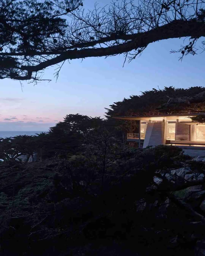
Big Sur Hotels (recommendations: Post Ranch Inn, Big Sur River Inn, Ventana — brief notes)
For a more luxurious experience, Big Sur has a few standout hotels with top-tier service and amazing views:
- Post Ranch Inn – This high-end resort offers stunning cliffside views and is perfect for couples. It’s an iconic choice for a reason!
- Big Sur River Inn – Located in a more serene part of Big Sur, this rustic inn provides a relaxing stay with a beautiful riverfront setting.
- Ventana Big Sur – Known for its relaxing atmosphere, this resort offers a mix of rooms, suites, and glamping tents, along with world-class amenities.
Recommended Restaurants & Cafés (Nepenthe, Big Sur Bakery, Sierra Mar — short descriptors)
After a long day of hiking or sightseeing, you’ll be ready to refuel with some delicious food. Big Sur has a range of restaurants and cafés that offer everything from casual bites to fine dining:
- Nepenthe – Known for its breathtaking views and delicious meals, Nepenthe is a must-visit. Try the Ambrosia Burger while taking in panoramic views of the ocean.
- Big Sur Bakery – This place is a hidden gem, offering fresh pastries, wood-fired pizzas, and a cozy ambiance.
- Sierra Mar – Located at Post Ranch Inn, this restaurant serves elevated cuisine with a side of jaw-dropping views. Perfect for a romantic dinner.
Must-See Stops in Big Sur
Big Sur is filled with incredible landmarks and hidden gems. From breathtaking cliffs to serene beaches, here’s a quick guide to the must-see stops, so you can plan your trip accordingly.
Bixby Creek Bridge
Why Visit: Bixby Creek Bridge is one of the most iconic and photographed spots on the Pacific Coast Highway. The bridge is 279 feet tall and spans a gorge with stunning views of the ocean and cliffs below. It’s a perfect stop for photos, especially around sunset.
Tip: Be prepared for crowds since it’s a popular spot, but it’s worth the wait for that iconic shot.
Point Lobos State Natural Reserve
Why Visit: Point Lobos is often referred to as the “crown jewel” of California’s state parks. It’s a fantastic spot for hiking, wildlife watching, and soaking in the gorgeous views of the coast. You’ll see sea otters, harbor seals, and a variety of seabirds.
Tip: Take the Bird Island Trail for the best ocean views and wildlife sightings.
McWay Falls (Julia Pfeiffer Burns State Park)
Why Visit: This 80-foot waterfall cascades directly onto a sandy beach, making it one of Big Sur’s most famous landmarks. The view from the observation point is absolutely breathtaking and something you won’t forget.
Tip: The best view of McWay Falls is from the roadside, as the main viewing platform is under renovation.
Pfeiffer Beach
Why Visit: Known for its purple sand and unique rock formations, Pfeiffer Beach is one of the most photogenic beaches in Big Sur. It’s also famous for the Keyhole Arch, where the sun creates an incredible light show during sunset.
Tip: The beach gets crowded, so try to visit early or late in the day for a more peaceful experience.
| Stop | Best Time | Parking | Fee |
|---|---|---|---|
| Bixby Creek Bridge | Sunset | Limited (Popular) | Free |
| Point Lobos State Reserve | Morning/Noon | Parking available | $10 |
| McWay Falls | Anytime | Limited (Popular) | $10 |
| Pfeiffer Beach | Sunset | Small parking lot | Free |
Final Thoughts on the Big Sur Road Trip
Big Sur is one of those places that truly lives up to the hype. Whether you’re there for a day trip or spending a few days exploring the stunning coastline, the views, the hikes, and the unforgettable experiences will stay with you long after you’ve left. The beauty of Big Sur is in its raw, untamed nature — from the dramatic cliffs to the peaceful beaches, it’s a road trip like no other.
If you’re planning your adventure, remember to stay safe, respect the environment, and leave no trace. Big Sur is an iconic destination that deserves to be preserved for future generations. So, take your time, enjoy the journey, and most importantly — have fun!
FAQs
1. What is Big Sur known for?
Big Sur is famous for its breathtaking coastline, scenic Pacific Coast Highway, and dramatic cliffs, offering some of the best ocean views in California. The area is also known for its redwood forests, wildlife, and iconic landmarks like McWay Falls and Bixby Creek Bridge.
2. How long does it take to drive the Big Sur route?
The Big Sur route along Highway 1 takes about 2-3 hours to drive without stops. However, to truly enjoy the beauty, it’s recommended to take a full day or more, as there are numerous scenic spots and hikes along the way.
3. Is it safe to drive through Big Sur?
While the drive through Big Sur is safe, it does come with some challenges like narrow roads, winding curves, and occasional fog. Always drive with caution, especially during bad weather. It’s best to check road conditions before your trip, as landslides and closures can happen.
4. When is the best time to visit Big Sur?
The best time to visit Big Sur is between April and October when the weather is mild. Spring offers wildflowers in bloom, while fall gives you fewer crowds and great whale-watching opportunities.
5. Can you visit Big Sur in one day?
Yes, you can drive the Big Sur coastline in one day, but it’s best to plan for a longer visit. With only one day, you’ll need to focus on the major stops like McWay Falls, Bixby Bridge, and Pfeiffer Beach.
6. What are the best places to stop in Big Sur?
Top stops include Point Lobos State Natural Reserve, Bixby Creek Bridge, Pfeiffer Beach, McWay Falls, and Julia Pfeiffer Burns State Park. These spots offer scenic viewpoints, hiking trails, and the chance to spot local wildlife.
7. Do I need a permit to visit Big Sur?
Most state parks in Big Sur require an entry fee, typically around $10–$15. For Pfeiffer Beach, there is also a small parking fee. Some areas, like Point Lobos, require advanced reservations during peak seasons.
8. Can I drive Big Sur in a rental car?
Yes, you can definitely drive Big Sur in a rental car. However, keep in mind that some of the roads are narrow and winding. If you plan to explore the back roads or go hiking, ensure your rental car is comfortable for those conditions.
9. Are there gas stations in Big Sur?
There are a few gas stations along the Pacific Coast Highway in Big Sur, but they’re limited. It’s best to fill up your tank before entering more remote areas, especially if you’re planning a longer drive.
10. How do I avoid crowds in Big Sur?
To avoid crowds in Big Sur, try to visit on weekdays and early in the morning or late in the afternoon. Popular spots like Pfeiffer Beach and McWay Falls get crowded during peak times, so visiting during off-peak seasons also helps.
11. Is there cell service in Big Sur?
Cell service is limited in many parts of Big Sur. Download offline maps ahead of time to navigate without relying on your phone. You may also encounter spotty service in certain areas, so having a paper map as backup is a good idea.
12. What wildlife can I see in Big Sur?
Big Sur is home to a variety of wildlife, including sea otters, harbor seals, California condors, and whales. The best times for whale watching are between December and April when gray whales migrate along the coast.