Bixby Bridge Big Sur: The Complete Visitor Guide (History, Views, Parking + Tips)
If you are driving Highway 1 through Big Sur, Bixby Bridge is the one stop you cannot skip. It is one of the most photographed bridges in the United States, it is completely free to visit, and the views it offers over the Pacific Ocean are the kind that stay with you long after you leave California. I have driven this stretch of Highway 1 multiple times over the years, and every single time I pull into that north-side turnout and look out at that concrete arch framing the ocean, I get the same feeling. It never gets old.
This guide covers everything you need to know before you go: the history behind the bridge, where to park, the best viewpoints for photos, what time to visit, nearby things to do, and the honest tips that will save you time and frustration on the day.
Quick Trip Facts
| Detail | Info |
|---|---|
| Full name | Bixby Creek Bridge |
| Location | Highway 1, about 15 miles south of Carmel-by-the-Sea |
| Address for GPS | Bixby Creek Bridge, Big Sur, CA 93920 |
| Entrance fee | Free |
| Best time to visit | Sunrise or golden hour, one hour before sunset |
| Crowds | Heavy in summer, lighter on weekdays before 9 AM |
| Time needed | 20 to 45 minutes for photos, longer if you plan to hike |
| Nearest town | Carmel-by-the-Sea, about 30 minutes north |
| Cell service | Very limited, download your maps before you leave Carmel |

Why Is Bixby Bridge So Famous?
Bixby Bridge is famous because there is simply nothing else that looks quite like it. The bridge rises over a deep canyon carved by Bixby Creek, with the Pacific Ocean on one side and the Santa Lucia Mountains on the other. When you stand at the north-side turnout and look south, you get this sweeping view of a perfectly proportioned concrete arch sitting inside one of the most dramatic stretches of coastline in the world. No photo fully prepares you for it.
In terms of California bridges, it is second only to the Golden Gate Bridge in fame and recognizability. Hollywood figured this out early. The bridge has appeared in dozens of films and car commercials over the decades, from The Sandpiper in 1965 and Play Misty for Me in 1971 to HBO’s Big Little Lies in 2017, where it opened every episode and introduced millions of new visitors to Big Sur. Car brands like BMW and Mercedes have used it as a backdrop for decades because it says one thing clearly: the open road at its best.
What most visitors do not know is that in 1965, when this stretch of road between Carmel Highlands and the Monterey County south border was declared California’s very first scenic highway, the dedication ceremony was held right here at Bixby Bridge. There is a plaque at the north-side parking area that marks it.
And if you have ever used a Mac, you have already seen this bridge. Bixby Bridge is the main image behind Apple’s macOS Big Sur operating system and appears in multiple Big Sur desktop wallpapers. It is one of the most quietly famous landmarks in the world.
Is Bixby Bridge Part of Big Sur?
Yes and no, and this is something that confuses a lot of visitors. Bixby Bridge sits at the northern gateway to Big Sur, about 15 miles south of Carmel-by-the-Sea on California State Route 1. It is not deep inside Big Sur. Think of it as the beginning of the Big Sur coast on a southbound drive, the moment the road gets dramatic and you know you have officially arrived.
From Monterey, the bridge is roughly a 30-minute drive south. From San Francisco, plan on about 2.5 to 3 hours via Highway 1 or Highway 101 south to Carmel and then continuing south. From Los Angeles, the drive is closer to 5 hours north via Highway 101 to San Luis Obispo and then north on Highway 1.
A lot of people ask me whether to drive Big Sur north to south or south to north. I always recommend north to south if you are starting from San Francisco or Monterey, because you approach Bixby Bridge with the ocean on your right and the turnouts are easier to access from that direction.
Bixby Bridge History
The story of Bixby Bridge starts long before anyone laid a single piece of concrete. The creek and the surrounding land take their name from Charles Henry Bixby, a New York businessman who arrived on the Monterey Peninsula in 1868. He bought up large tracts of land along the Big Sur coast and spent years harvesting lumber there. The land, the creek, and eventually the bridge all carry his name.
For decades after Bixby’s time, the Big Sur coast was essentially cut off from the rest of California. There was no good coastal road. If you wanted to travel between northern and southern California through this area, you had to take a rough inland route that added 11 miles to your journey. That detour over mountain roads was slow, difficult, and expensive for goods and people moving up and down the coast.
In 1931, construction began on a bridge that would change that. Work started in August of that year and finished in October 1932, under the supervision of engineer C.H. Purcell and designer F.W. Panhorst, built by Ward Engineering Company. The timing matters: this was the middle of the Great Depression. Building a major concrete arch bridge in one of the most remote and rugged stretches of coastline in California, with the technology and equipment of the early 1930s, was an enormous undertaking. The numbers tell the story: 300,000 feet of timber, 600,000 pounds of reinforcing steel, and 45,000 sacks of cement. The total cost came in at just over $200,000.
When it opened, Bixby Creek Bridge was the highest single-span arch bridge in the world and the longest concrete arch bridge on any California state highway. Both records held for years.
The bridge has not had an easy life. The Big Sur coastline is geologically active and prone to landslides, and the highway at Bixby Bridge has become impassable multiple times over the years after major storms and slides. Even the annual Big Sur Marathon has been affected by road closures here. In 1998, the state undertook a major two-year seismic retrofitting project to strengthen the bridge against earthquakes. The challenge was doing that without altering the appearance of the original open-spandrel concrete arch. The result preserved the look completely, but the price tag came in at nearly $20 million, a far cry from the original $200,000 build.

Bixby Bridge Facts at a Glance
| Fact | Detail |
|---|---|
| Height | 260 feet above Bixby Creek |
| Total length | 714 feet |
| Construction cost | About $200,000 in 1932 |
| Seismic retrofit cost | About $20 million, completed 2000 |
| Bridge type | Reinforced concrete open-spandrel arch |
| Also known as | Bixby Creek Bridge, Mill Creek Bridge, Rainbow Bridge |
| Engineering designation | Historic Civil Engineering Landmark, ASCE |
| Famous appearances | Big Little Lies, Play Misty for Me, The Sandpiper, macOS Big Sur |
Is Bixby Bridge Worth Visiting?
Yes, without any hesitation. But let me give you the honest version, because I think visitors deserve that more than a simple yes.
The case for going is strong. It is free. You do not need to book anything. Even if you only pull over for 15 minutes, the views are genuinely unforgettable. The sound of the ocean below the bridge, the scale of the canyon, and the way the arch frames the coastline in both directions is the kind of scene that earns its reputation. I have visited with photographers carrying expensive cameras and with friends who only had their phones, and everyone walks away with something worth keeping.
You can also build Bixby Bridge into a full day easily. Combine it with McWay Falls at Julia Pfeiffer Burns State Park, a walk at Point Lobos State Natural Reserve, and a stop at Pfeiffer Beach and you have one of the best one-day drives in California.
Now here is the honest part. The bridge has no pedestrian walkway. It is an active two-lane highway and you cannot walk across it. All viewing and photography happens from the turnouts on either side. If you arrive expecting to walk out onto the bridge and look down, you will be disappointed. A lot of people do not know this until they get there.
The crowds can also be significant, especially on summer weekends and at sunset. Parking is limited and it fills up fast. If you arrive at noon on a Saturday in July, you may find the north-side lot completely full. And because parking on the highway shoulder is both dangerous and illegal, that can mean driving past and missing the best viewpoint.
None of this makes it not worth visiting. It absolutely is. But if you go in knowing about the walkway situation and the parking challenge, you can plan around them.

Best Time to Visit Bixby Bridge
The bridge looks beautiful in every season, but the timing of your visit makes a big difference in what you experience.
For the season, my recommendation is spring, specifically April and May. The mountains behind the bridge turn a deep, saturated green after winter rain, and wildflowers grow along the hillsides around the viewpoints. The crowds are lighter than summer and the weather is usually mild. September through November is also excellent: the summer rush is over, parking is easier to find, and the light in fall is especially warm in the late afternoon.
Summer from June through August is peak season. The bridge is gorgeous but the parking lots fill quickly, particularly on weekends. If you are visiting in summer, arriving before 9 AM is the best strategy. You will get the morning light on the arch, the mountains are visible before any afternoon marine layer rolls in, and there will be far fewer people competing for the same view.
For time of day, golden hour is the clear winner. The hour before sunset casts warm light on the concrete and the surrounding cliffs and creates the most photogenic conditions. Sunrise is equally good if you are willing to get up early, and you will almost certainly have the viewpoint to yourself. Midday light is flat and the crowds are at their worst.
One thing I want to say about fog, because most travel guides treat it as something to avoid: fog at Bixby Bridge can be spectacular. When the marine layer rolls in low over the canyon in the morning and the arch of the bridge rises above it, the result is moody and cinematic in a way that clear sunny days cannot replicate. If you arrive and find fog, do not leave immediately. Give it time. Watch it move. Some of the best photos I have seen from this bridge were taken in heavy fog.
Always check the weather before you go. Conditions on this coast change quickly and what starts as a clear morning in Carmel can become a foggy afternoon at Bixby.
How to Get to Bixby Bridge
The only practical way to reach Bixby Bridge is by car. There is no public transit that comes close to this part of the Big Sur coast, and the distances involved make any other option impractical.
Put this into your GPS: Bixby Creek Bridge, Big Sur, CA 93920.
From Monterey, head south on Highway 1 for about 20 miles. The drive takes roughly 30 minutes under normal conditions.
From San Francisco, take Highway 101 south or Highway 1 south through Half Moon Bay. The coastal route is more scenic but adds time. From the city, plan on 2.5 to 3 hours.
From Los Angeles, take Highway 101 north to San Luis Obispo and then pick up Highway 1 north through Cambria and San Simeon. The drive is about 5 hours.
One critical thing to do before you leave: download your maps offline. Cell service drops out quickly once you leave Carmel and heading south into Big Sur, you will have long stretches with no signal at all. If you are relying on a live navigation app, you will lose it right when the roads get more complex. I always download the offline map for the entire Big Sur stretch the night before I drive it.
Also check Caltrans road conditions before you go, especially if you are traveling after winter rain or storms. Highway 1 through Big Sur has a long history of landslide closures, and the road can close without much warning. The Caltrans QuickMap at quickmap.dot.ca.gov is the most reliable place to check current conditions.

Bixby Bridge Parking
Parking is the question I get asked about more than anything else when it comes to Bixby Bridge, and for good reason. The options are limited and the demand is high. Here is what you need to know.
North-side ocean pullout is the main parking area and the most popular spot. It sits on the ocean side of Highway 1 at the northern end of the bridge and has several marked spaces. This is where you get the classic view: the bridge arch in the foreground, Santa Lucia Mountains behind it, Pacific Ocean to the left. From this pullout you can also see the commemorative plaque marking California’s first scenic highway dedication in 1966. This lot fills up fast on weekends and summer afternoons. Get here before 9 AM if you want to guarantee a space.
South-side turnout is a smaller pullout on the south end of the bridge. It gives you a reverse view of the bridge and tends to be less crowded because most visitors pull over at the north side without realizing this option exists. The angle is different and worth checking, especially if the north lot is full.
Hurricane Point vista is about a mile south of the bridge, where Highway 1 climbs up the hillside. There is a pullout at the top that gives you a wide, elevated view of Bixby Bridge set within its full coastal context. It is a more distant view, so bring a zoom lens if you want close-up shots, but this is where you get the big panoramic image that shows the bridge, the canyon, the cove, and the coastline all together. It is one of the best views on the entire coast and most visitors drive right past it.
If the north-side lot is full when you arrive, do not park on the highway shoulder. It is dangerous and you will be ticketed. Your best option is to continue south to Hurricane Point, park there, enjoy the panoramic view, and then drive back north when a space opens up.
Parking at all of these spots is free.
Best Viewpoints for Bixby Bridge Photos
This is the section I wish every article about Bixby Bridge included, because most of them only mention one or two spots. There are five distinct viewpoints and each one gives you a completely different image.
North-side ocean pullout is the classic. Bridge framed by mountains on the east, ocean on the west, shot from close range. Best in the morning when the light comes from the east and hits the arch directly. This is the shot you have seen in every travel magazine.
East side of the highway is just across the road from the north pullout. Standing here, you face west toward the ocean and the bridge is silhouetted against the water. At sunset this view is extraordinary. The arch goes dark against a bright sky and the ocean turns gold and orange behind it. It is a completely different image from the classic north-pullout shot and most visitors never cross the road to find it.
West side mountain backdrop is the view from the east side of the highway where the mountains form the entire background. No ocean, just the bridge rising in front of the Santa Lucia range. Good for shots that emphasize the scale and engineering of the structure rather than the coastal setting.
Bixby Bridge Vista Point on Old Coast Road is the one that separates the serious photographers from the casual visitors. About half a mile inland from the bridge, accessible via the Old Coast Road turnoff, there is a vista point where you are parallel with the bridge looking at it head-on. You can walk or drive there if your vehicle handles unpaved road. The perspective from here is completely different from anything you can get at the highway turnouts, and most people never know it exists.
Hurricane Point about a mile south is where you get the big picture. The bridge is small in the frame but the context is everything: the sweep of the coastline, the canyon, the cove, the arch sitting inside this enormous natural landscape. Bring a longer lens to pull the bridge closer in the frame. Best on clear days when the full view is visible.
A few photography notes. The concrete of the bridge was built in shades of tan specifically to blend with the surrounding cliffs, so it photographs well in any light. Morning fog is not your enemy. When the marine layer sits low in the canyon and the bridge rises above it, the images are genuinely dramatic. Do not leave just because it is cloudy. Stay within the designated viewing areas and keep well back from the cliff edges. The cliffs in this area are fragile and unstable, and signs are there for a reason.

Things to Do Near Bixby Bridge
Bixby Bridge is best experienced as part of a longer day on the Big Sur coast rather than as a standalone stop. Here are the nearby attractions worth adding to your itinerary, organized by direction and distance.
North of the bridge:
Point Lobos State Natural Reserve is about 10 miles north and is one of the most beautiful coastal parks in California. There are short trails through cypress groves, dramatic coves, tide pools, and regular sea otter sightings. Reserve a day-use parking pass online before you go because it fills up fast in summer.
Garrapata State Park and Beach is just a few miles north of the bridge and has easy coastal trails accessible to all fitness levels. The beach here is wild and uncrowded compared to more famous Big Sur beaches.
South of the bridge:
Point Sur Lightstation is about 10 miles south. Tours run on Wednesdays and Saturdays only and book out quickly. If you are interested in Big Sur history and lighthouse architecture, this is worth planning ahead for.
Andrew Molera State Park is about 15 miles south and is where the Old Coast Road hiking trail from Bixby Bridge ends. It also has its own coastal trails, a beach, and redwood groves.
Pfeiffer Beach is about 20 miles south and is famous for its purple sand and the Keyhole Rock, a large sea stack with a natural arch. Visit at golden hour to catch the sun coming through the rock. There is a day-use fee and the turnoff is easy to miss, so watch for the Sycamore Canyon Road sign.
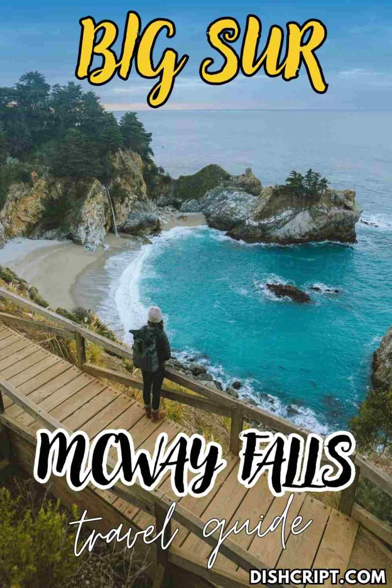
McWay Falls at Julia Pfeiffer Burns State Park is about 30 miles south and is one of the most photographed spots in Big Sur after Bixby Bridge itself. It is one of only two waterfalls in California that fall directly into the ocean. The walk from the parking area is short and easy.
Nepenthe Restaurant is about 25 miles south and sits on a cliff above the ocean. The views from the terrace are exceptional and the food is good. Stop here for lunch or an early dinner on your way south.
Big Sur Bakery is closer to Pfeiffer Big Sur State Park and is a reliable stop for coffee and pastries early in the morning or as a snack break mid-drive.

Old Coast Road Hike from Bixby Bridge
This is the section that almost no travel guide about Bixby Bridge includes, and it is a genuine hidden gem for anyone who wants to explore beyond the highway turnouts.
The Old Coast Road trailhead starts right at the bridge. The route heads inland and uphill into the mountains, following Bixby Creek, passing through forest, and offering elevated views back toward the bridge and the coast that you simply cannot get from the highway. The full trail is about 10 miles and ends near Andrew Molera State Park to the south.
It is also a popular four-wheel drive route, so if you have a high-clearance vehicle you can drive it. If you are hiking, plan for about 4 to 5 hours for the full one-way route. Wear proper hiking shoes because the trail surface is uneven and the terrain changes significantly from the coastal scrub near the bridge to forested sections further inland.
Bring water, snacks, and sun protection. Download an offline map of the trail before you start because there is no cell service once you leave the highway. If you are doing the full route and leaving a car at Andrew Molera, arrange the logistics before you set out.
Even if you only walk the first mile inland before turning around, the views back toward the bridge and the ocean are worth the effort.
Where to Stay Near Bixby Bridge
There are no hotels at the bridge itself. Your accommodation options depend on whether you want to stay north in Carmel or further south in Big Sur.
Carmel-by-the-Sea is the most practical base for most visitors. It is about 30 minutes north of the bridge and has a wide range of luxury inns, boutique hotels, and bed and breakfasts. The town is beautiful, walkable, and full of good restaurants. This is my recommendation for first-time visitors who want comfort and convenience.
Big Sur Lodge is inside Pfeiffer Big Sur State Park, about 25 miles south of the bridge. It is mid-range in price, well-located for exploring the southern part of the coast, and surrounded by redwood forest. Book well in advance for summer.
Ventana Big Sur is a high-end resort about 25 miles south with canyon and ocean views. It is genuinely one of the most beautiful resort properties in California. Expensive, but worth it if this is a special trip.
Post Ranch Inn is also about 25 miles south and is considered one of the top luxury hotels in the United States. Cliffside rooms, extraordinary views, excellent food. Book months in advance.
If you are camping, Pfeiffer Big Sur State Park has campground reservations through ReserveCalifornia.com. It fills up extremely fast in summer, sometimes months out. Check early.
Important Travel Tips
Download offline maps in Carmel before you head south. I cannot say this enough. Cell service is unreliable throughout Big Sur and disappears completely in many sections. If you are navigating live, you will lose your signal at the worst possible moment.
Check Caltrans road conditions at quickmap.dot.ca.gov before every Big Sur drive, especially from November through April. The highway has a history of sudden closures from landslides and storm damage. A quick check before you leave saves hours of frustration.
Fill your gas tank in Carmel or Monterey. Gas stations in Big Sur are rare and the prices are significantly higher than anywhere else on the Central Coast. Do not assume you can find gas easily once you head south.
Arrive at Bixby Bridge before 9 AM on weekends or holidays if you want a guaranteed parking spot at the north-side pullout. The lot is small and summer crowds are intense.
Never stop on the bridge itself. There is no pedestrian walkway, it is an active two-lane highway, and stopping on the roadway is both illegal and dangerous. All viewing is done from the designated turnouts.
Bring layers even in summer. The coast at Bixby is frequently windy and the marine layer can make it feel much colder than the temperature suggests. A light jacket and wind layer will keep you comfortable.
If the north parking lot is full when you arrive, drive south about a mile to Hurricane Point instead of parking on the shoulder. The panoramic view from Hurricane Point is genuinely spectacular on its own terms and well worth the stop.
Stay within marked viewing areas near the cliff edges. The cliffs at Bixby are unstable. Barriers and fencing exist for safety reasons.
FAQs
Why is Bixby Bridge so famous?
Bixby Bridge is famous for combining extraordinary engineering with one of the most dramatic coastal settings in the United States. It is the second most photographed bridge in California after the Golden Gate, has appeared in major films and TV shows for over 50 years, was the site of California’s first scenic highway dedication in 1965, and is the face of Apple’s macOS Big Sur operating system. It is also simply beautiful.
Is Bixby Bridge part of Big Sur?
Yes, it sits at the northern gateway to the Big Sur coast, about 15 miles south of Carmel-by-the-Sea on Highway 1. It marks the beginning of the Big Sur coastline on a southbound drive and is often called the gateway to Big Sur.
Is Bixby Bridge worth visiting?
Yes, absolutely. It is free, it takes only 15 to 20 minutes at minimum, and the views are genuinely unforgettable. The honest caveats are that there is no pedestrian walkway on the bridge itself and parking is limited on busy weekends. Plan around those two things and you will have a great experience.
Where is the best viewpoint for Bixby Bridge?
The north-side ocean pullout gives you the classic close-up shot with mountains behind the arch. The east side of the highway at sunset gives you a silhouette view against the ocean. Hurricane Point about a mile south gives you the wide panoramic view. The Bixby Bridge Vista Point on Old Coast Road gives you a head-on perspective that most visitors never find.
Is there a fee to visit Bixby Bridge?
No. The bridge and all viewing pullouts are free to access.
Can you walk across Bixby Bridge?
No. The bridge is an active two-lane highway with no pedestrian walkway. Do not attempt to walk across it.
How far is Bixby Bridge from Monterey?
About 20 miles south of Monterey. The drive on Highway 1 takes roughly 30 minutes.
Is Bixby Bridge open right now?
The bridge itself is generally open year-round, but Highway 1 through Big Sur is prone to closure after storms and landslides. Before any visit, check current road conditions at quickmap.dot.ca.gov for the most accurate and up-to-date information.
Final Thoughts
Bixby Bridge earns every bit of its reputation. I have stood at that north-side turnout more times than I can count and it has never once felt ordinary. Whether you are a photographer chasing the perfect coastal image, a road tripper ticking off a bucket list stop, or a first-time California visitor trying to understand what makes Highway 1 so special, this bridge delivers.
The best version of a Bixby Bridge visit is one where you arrive early, give yourself time to walk both sides of the pullout, and stay long enough to watch the light change. Add McWay Falls and Point Lobos and you have one of the best driving days California offers.
If you are ready to plan your Big Sur road trip, start here.